TZ Odyssey Wide
TZ Odyssey is our entry-level product that is based on the revolutionary TIMEZERO technology, and NOAA raster and vector charts are included for free for all US waters.
TIMEZERO chart engine:
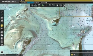
The TIMEZERO chart engine allows you to pan and zoom with lightning speed. It features full 3D chart rendering, allowing users to choose the traditional 2D top-down view of the navigation chart or switch to a 3D view for a wider field of vision. Pan and zoom across the chart to instantly view it in any angle at any scale range. There is no limited “3D mode” because TZ Odyssey operates in a true 3D environment at all times.
mm3d navigation charts:
TZ Odyssey comes complete with charts that cover the entire US coast, including Alaska, Hawaii, the Pacific Islands and Great lakes.
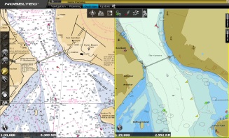
Odyssey uses MapMedia mm3d charts, which give users the opportunity to choose from multiple chart sources such as official S-57 vector and raster charts from hydrographic offices around the world. Vector charts from C-MAP by Jeppesen and DataCore by Navionics are also available.
This software also features the patented PhotoFusion: an intelligent mix of marine charts, 3D data and satellite imagery to give you the best possible information at all times.
TZ Odyssey provides a range of features for safe navigation:
- GPS positioning
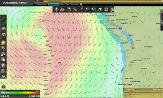
- Weather forecast (GRIB files)
- Free worldwide tide database
- Management of Routes and Waypoints
- AIS function
Features
- Connection to instruments: Serial ports (NMEA0183, NMEA 2000) or the Furuno NavNet network by Ethernet (for navigation information only)
- Marks and Routes transfer to GPS (**)
- Exclusive TIMEZERO chart engine: real-time navigation, native 3D chart view and seamless chart redraw
- Includes a complete set of US Charts (NOAA RNC raster charts and ENC vector charts), 3D data and high resolution satellite photos (*)
- PhotoFusion: an intelligent mix of satellite photos and nautical charts
- Unlimited Vessel Track Recording and Track Line Coloring (with track recall feature)
- Unlimited Marks, Waypoints, Routes, Boundaries, Circles, Lines and Annotations
- POIs: integration with ActiveCaptain, the interactive cruising guidebook – see www.ActiveCaptain.com, and AIS online and even save your own photos to the chart
- Free Nobeltec Weather Service (GRIB files): rain, cloud coverage, air temperature, wind, waves, oceanic currents, pressure
- Alarms: anchor alarm, AIS CPA/TCPA alarm, depth alarm and more
Options available:
- Sailing Plus Pack
- USB GPS
- Bahamas Explorer Charts
- See full chart catalog here: www.mapmedia.com