Description
Fast, Really Fast
Nobeltec’s TIMEZERO Trident uses a new, ultra-fast cartographic engine that you really have to see to believe.
The TIMEZERO engine redraws charts seamlessly allowing you to easily zoom, pan, change chart display modes and perform other chart handling functions without any limited range presets.
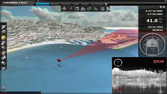
Full-time 3D environment
TIMEZERO Trident features a whole new dimension in chart presentation with full time 3D chart rendering. The user can choose a 2D top-down view of the navigation chart for a traditional chart-plotter display, or switch quickly to 3D mode for a wider field of vision.
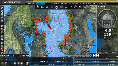
PhotoFusion
This innovative feature allows you to navigate over raster or vector charts while viewing high resolution photography. Land areas (zero depth) are displayed as high-resolution satellite photos on the chart.
As the depth increases, the photos become more transparent allowing you to see where shallow water ends and deeper water begins. This is an invaluable aid in identifying sand, rocks, coral and other obstructions found in shallow water.
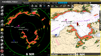
Hardware Integration
TZ Trident allows an advanced level of hardware integration that will respond to the needs of a wide range of users. Yacht owners can enjoy full integration with the Furuno NavNet 3D, NavNet TZTouch or the Nobeltec InSight range of radars.
Professional tug boats can integrate their commercial-grade FURUNO FAR 2xx7 series radars. It is also possible to integrate FLIR M-Series thermal cameras to display the real-time image and even track targets through the software. This provides unparalleled security for professional users.
Features
- Connection to instruments: NMEA0183, NMEA2000 or Furuno NavNet network by Ethernet (for navigation information)
- Exclusive TIMEZERO chart engine (Real Time Navigation, Native 3D View and seamless chart redraw without limited range presets)
- Includes a complete set of US Charts (Raster and Vector), 3D and High Resolution Satellite Photos (**)
- Dual Monitor Support
- Customizable User Interface
- Unlimited Marks, Waypoints & Routes, boundaries, circles etc.
Marks and Routes transfer to GPS (***) - Free Nobeltec GRIB Weather and Ocean data service (Rain, Cloud, Air Temperature, Wind, Waves, Oceanic Currents, Pressure, SST, Altimetry)
- POIs: integration with ActiveCaptain, AIS Online and Google Panoramio.
- Alarms (Anchor Alarm, CPA/TCPA Alarm, Depth Alarm, and more)
- AIS and MARPA Target Display (with targets list)
- Digital Selective Calling (DSC) and Man Over Board (MOB) device integration
- AXIS IP Cameras and video converter Support
- FLIR thermal camera integration (M-Series Control and Tracking)
- Advanced hardware integration available with Plus Packs listed below.
Plus Packs:
Furuno Radar Plus Pack:(Included)
- NavNet 3D and TZ Touch DRS(*) and FAR2XX7 network connection (view and control the radar)
- NavNet3D and TZ Touch Chart Server (Nobeltec streaming charts to any NavNet 3D MFDs)
- Shared Charts Licensing with NavNet 3D and TZ Touch
- Route synchronization with NavNet 3D and TZ Touch
- Full Screen Radar Work Space and 3D Radar Overlay
Furuno Network Sounder:
- DFF1, DFF3, FCV1150 and BBDS1 Network Connection (view and control the sounder)
- Full Screen Sounder Work Space with echogram history
TZ InSight Radar Plus Pack (****)
- Full Nobeltec InSight range of Ethernet-based radars (with link)
- Display, control and overlay the radar directly from Trident software.
Notes:
(*) MFD required
(**) Vector Chart coverage subject to available NOAA ENC. High Resolution Satellite Photos available as a free download
(***) Standard NMEA0183 $xxWPL and $xxRTE sentences are used for the transfer. Check your GPS specifications for compatibility
(****) Free option with InSight Radar purchased from Nobeltec