Description
Easy to use software
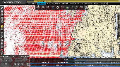
TZ SportFishing is based on the TIMEZERO chart engine, allowing you to pan and zoom across the chart extremely quickly and without any chart redraw.
The user interface is customizable, so you can choose which tools and navigation data are displayed at any time. Easily create a new route and overlay Nobeltec’s free weather forecast data on the chart so that you can plan your next trip accordingly.
All NOAA raster and vector charts are included for free in the mm3d format, for US waters. These also come with high-resolution satellite photos and 3D data.
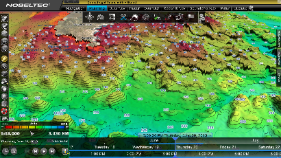
Bathy Recorder
Create your own bathymetric charts with TZ SportFishing. All you need to do is connect your NMEA 0183 or 2000 depth transducer, and you can begin recording. Your bathy database will be updated in real-time, so every time you take a fishing trip, you will improve the quality of your bathy chart for those fishing grounds. By mapping the contours of the sea floor, you discover the exact spots that fish are most likely to be found.
SportFishing allows you to switch between 2D and 3D when viewing your bathy chart, and by activating depth shading, you can clearly identify each contour.
Seamless advanced hardware integration
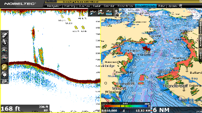
With TZ SportFishing, you have the option to integrate a range of radars, sounders, MFDs and even AXIS IP cameras.
It supports Nobeltec InSight radars and the Furuno FAR2XX7 class radars so you can display, overlay and control the radar directly from your computer. SportFishing also integrates with Furuno Ethernet sounders, the NavNet3D and TZtouch chart plotters, standard NMEA 0183 navigation sensors, and NMEA 2000 networks.
Features
- Connection to instruments: Serial ports (NMEA0183, NMEA 2000) or FURUNO NavNet/ TZ Touch network by Ethernet
- Exclusive TIMEZERO chart engine (redraws charts and marks instantly)
- Includes a complete set of US Charts (NOAA RNC raster charts and ENC vector charts), 3D and high resolution satellite photos (**)
- mm3d C-MAP by Jeppesen vector chart compatibility
- mm3d DataCore by Navionics vector chart compatibility
- Dual monitor support
- Customizable User Interface
- Unlimited Vessel Track Recording and Track Line Coloring (with track recall feature)
- Bathy Recorder
- Free Nobeltec Weather and Ocean Data Service (Rain, Cloud Coverage, Air Temperature, Wind, Waves, Oceanic Currents, Pressure, SST, Altimetry)
- Alarms (Anchor Alarm, CPA/TCPA Alarm, Depth Alarm, and more)
- AIS and MARPA target display (with targets lists)
- Digital Selective Calling (DSC) and Man Over Board (MOB) device integration
Plus Packs:
Furuno Radar Plus Pack: (Included)
- NavNet 3D and TZ Touch DRS(*) and FAR2XX7 network connection (view and control the radar)
- NavNet3D and TZ Touch Chart Server (Nobeltec streaming charts to any NavNet 3D MFDs)
- Shared Charts Licensing with NavNet 3D and TZ Touch
- Route synchronization with NavNet 3D and TZ Touch
- Full Screen Radar Work Space and 3D Radar Overlay
Furuno Network Sounder:
- DFF1, DFF3, DFF1-UHD, FCV1150 and BBDS1 Network Connection (view and control the sounder)
- Full Screen Sounder Work Space with echogram history
TZ InSight Radar Plus Pack (**)
- Full Nobeltec InSight range of Ethernet-based radars (with link)
- Display, control and overlay the radar directly from Sportfishing software.
Notes:
(*) MFD required
(**) Free option with InSight Radar purchased from Nobeltec