Description
The complete solution for commercial fishing
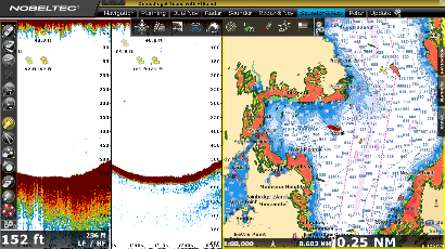
TZ Catch offers a powerful all-in-one solution for fishermen. It features the extremely fast TIMEZERO chart engine, allowing for seamless panning and zooming on the chart. It also comes complete with free NOAA raster and vector charts for US waters.
Advanced Features for Increased Profitability
- Full control of your Furuno DFF1, DFF3, DFF1-UHD, FCV1150 or BBDS1 Sounder to generate images of the seafloor bottom and water columns to detect fish
- Integrated Radar control with the Furuno NavNet3D/TZ Touch and FAR2XX7 series radars and Nobeltec InSight radars
- Commercial-grade Bathy Recorder
- Free ocean data including Sea Surface Temperature and Altimetry
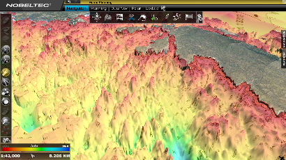
- High Resolution 3D Database available for selected areas
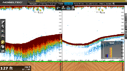
Bathy Recorder
The Commercial Grade Bathy Recorder allows you to integrate NMEA 0183 Depth Transducers or Furuno DFF1, DFF3, DFF1-UHD, FCV1150 or BBDS1 Sounders with your navigation computer. Using real-time depth data from your transducer, constantly build the contours of your charts. Use this data to help you discover new fishing areas and know your favorite fishing sites better. There is no limit to the number of points the software can record, allowing the user to create the most precise bathy charts possible.
Advanced Bathy Recorder settings can be adjusted, such as keel draft, and several quality filters can be set up. It’s also possible to delete any points that you do not want for any reason.
Easily import/share Nobeltec navigation/bathymetric data.
Advanced Layer Management
Advanced Marks and Layers Management allows you to filter marks, tracks and other fishing information that are in view on the screen. Use Catch to selectively display marks and all of you previous tracks to help reveal where you have been fishing. Color or categorize these tracks in different layers to find prime fishing locations.
Features
- Connection to instruments: Serial ports (NMEA0183, NMEA 2000) or FURUNO NavNet/ TZ Touch network by Ethernet
- Exclusive TIMEZERO chart engine (redraws charts and marks instantly)
- Includes a complete set of US Charts (NOAA RNC raster charts and ENC vector charts), 3D and high resolution satellite photos (**)
- mm3d C-MAP by Jeppesen vector chart compatibility
- mm3d DataCore by Navionics vector chart compatibility
- Dual monitor support
- Worldwide tide database
- US tidal currents
- Customizable User Interface
- Unlimited Vessel Track Recording and Track Line Coloring (with track recall feature)
- Advanced Layer and Marks Management
- Advanced Bathy Recorder
- Custom High Resolution Contour Lines
- Free Nobeltec Weather and Ocean Data Service (Rain, Cloud Coverage, Air Temperature, Wind, Waves, Oceanic Currents, Pressure, SST, Altimetry)
- Alarms (Anchor Alarm, CPA/TCPA Alarm, Depth Alarm, and more)
- AIS and MARPA target display (with targets lists)
- Digital Selective Calling (DSC) and Man Over Board (MOB) device integration
Plus Packs:
Furuno Radar Plus Pack: (Included)
- NavNet 3D and TZ Touch DRS(*) and FAR2XX7 network connection (view and control the radar)
- NavNet3D and TZ Touch Chart Server (Nobeltec streaming charts to any NavNet 3D MFDs)
- Shared Charts Licensing with NavNet 3D and TZ Touch
- Route synchronization with NavNet 3D and TZ Touch
- Full Screen Radar Work Space and 3D Radar Overlay
Furuno Network Sounder:
- DFF1, DFF3, DFF1-UHD, FCV1150 and BBDS1 Network Connection (view and control the sounder)
- Full Screen Sounder Work Space with echogram history
TZ InSight Radar Plus Pack (***)
- Full Nobeltec InSight range of Ethernet-based radars (with link)
- Display, control and overlay the radar directly from Catch software.
Notes:
(*) MFD required
(**) Vector Chart coverage subject to available NOAA ENC. High Resolution Satellite Photos available as a free download
(***) Free option with InSight Radar purchased from Nobeltec